Secret documents leaked by government departments to the ABC 7.30 Report reveal a very very serious explosive risk at the Chinchilla UCG plant. (Underground Coal Gasification)
There was an exclusion placed on 320 kilometers of land surrounding Linc's plant not to dig any deeper than 2 meters. This is because its all gone very very wrong. This is because it has become highly unstable.
Hydrogen and Methane and Hydrogen Sulfide have been found by the investigators.
UCG burns subterranean coal seams and converting this to Syngas. (Hydrogen monoxide)
AIR, AQUIFERS AND SOIL have been contaminated across a huge area by Linc Energy on some prime agricultural land. This is such a serious incident but it has taken an entire year for the report to be compiled.
Five CRIMINAL CHARGES are yet to be heard. Investigators leaked to ABC there are serious risks and the land is ruined due to acidification from toxic contaminants causing huge health and safety risks. Workers reported deteriorating health and they were constantly ill with headaches, some have left work because they were sick of being sick.
Linc Energy deny everything and they deserve to be put on a Bully Ants Nest ... this is very serious with fines of 5 million dollars and a term in jail. This should be prosecuted.
GLOBAL HEAD OFFICE
Linc Energy Ltd.
Smellie & Co Building
32 Edward Street
Brisbane, QLD, 4000, Australia
GPO Box 1315, Brisbane, QLD, 4001
Ph: +61 7 3229 0800
Fax: +61 7 3229 6800
CHINCHILLA OFFICE
Linc Energy Ltd.
357 Kummerows Road
Chinchilla, QLD, 4413, Australia
PO Box 469, Chinchilla, QLD, 4413
Ph: +61 7 4665 4175
Fax: +61 7 4665 418
Please READ the STORY HERE
bbbbbbb
Showing posts with label Natural Disasters and Hazards. Show all posts
Tuesday, August 18, 2015
Monday, March 30, 2015
Radiation Dump from our star, Earthquakes arrive!
Interactive map: Open
Earthquake Magnitude 7.2M, Depth:10kmon 29/03/2015 23:48 UTC 232322 people within 100km
Tsunami: The maximum Tsunami wave height is
Kaubademki, Papua New Guinea. This height is estimated for 30-Mar-2015 00:25:38.
- Global Disaster Alert and Co-Ordination System
- News.com.au
- International Tsumani Information Centre (ITIC)
- 1945 Makran Tsunami
Various hazard maps can be downloaded like this one above in PDF format from HERE
CURRENT TSUNAMI WARNINGS HERE
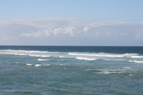
A normal day at the beach can look like this one minute and next minute the water starts disappearing into the ocean and appears like its not coming back. It is coming back and when it does it brings the full force of the oceans power with it.
When this happens there is GDACS who are Global Disaster Alert and CoOrdinaton Service: They provide a range of services.... GDACS provides alerts and impact estimations after major disasters through a multi-hazard disaster impact assessment service managed by the European Commission Joint Research Centre.
To this end, JRC establishes scientific partnerships with global hazard monitoring organisations. Flood disasters are provided by the Dartmouth Flood Observatory. Relevant data is integrated automatically into GDACS alerts and impact estimations.
When this happens there is GDACS who are Global Disaster Alert and CoOrdinaton Service: They provide a range of services.... GDACS provides alerts and impact estimations after major disasters through a multi-hazard disaster impact assessment service managed by the European Commission Joint Research Centre.
To this end, JRC establishes scientific partnerships with global hazard monitoring organisations. Flood disasters are provided by the Dartmouth Flood Observatory. Relevant data is integrated automatically into GDACS alerts and impact estimations.
GDACS develops standards and guidelines for international information exchange in disasters.
GDACS provides the real-time coordination platform “VirtualOSOCC” (http://vosocc.gdacs.org) to disaster managers worldwide. ![]() |
| Source: Volcán Popocatépetl |
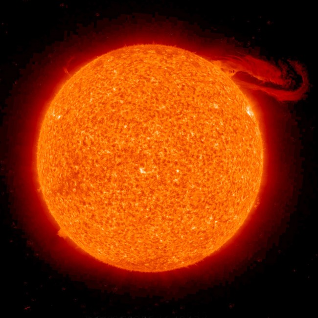
Due to the radiation dump from the Sun in the week leading up to this earthquake there are volcanic eruptions as well. The Colima Volcano in Mexico is going off at the moment.
This type of event is called a prominence eruption. It occurs in the extended, hot outer atmosphere of the sun, called the corona. The material that appears to glow red is plasma, a mix of electrically charged hydrogen and helium. Geeked on GoddardI believe that events like this huge coronal mass ejection trigger events here on Earth with volcanology. Volcanoes and Earthquakes and strange weather that has extremes seems to resonate to these bursts from the sun. The extremes this pushes weather to could be the best way to reach the mid point again and reconcile the energy. These rhythms are happening faster and faster now as the light changes from space faster and faster each day.
Images @ Eminpee Fotography Ocean
Labels:
Earthquake,
Natural Disasters and Hazards,
Papua,
Tsunami
URUNGA NSW
Urunga NSW 2455, Australia
Tuesday, May 01, 2012
"Earth and space are about to come into contact in a way that's new to human history."
According to Richard Fisher, head of NASA’s Heliophysics Division.
I am moving to the The New England area when I get back from Uluru. I am looking forward to this and to growing our own food again. I will probably suffer with the cold but that is better than drowning to death.
I am in preparation mode now and I must continue to be in such a state of flux because we are now officially on the move. The planetary shift is a reality and the earth has the lowest magnetic levels in 2000 years. The planets are lining up and this is going to make the water rise and fast and it will become a time without electricity.
We will become like aboriginals again. The sun and the Moon will be new. This is an exciting but terrifying time no less. Some won't even make the transition to the new ways.
My children are all grown up fairly well. Montana has a boyfriend and she and him may come up there when I am set up perhaps. That would be good.
I have much to write in a list form. I must firstly get a shed and perhaps this will be easy in the Glen Innes area.
Image by Mezza - Full Moon in Early April 2012
I am moving to the The New England area when I get back from Uluru. I am looking forward to this and to growing our own food again. I will probably suffer with the cold but that is better than drowning to death.
I am in preparation mode now and I must continue to be in such a state of flux because we are now officially on the move. The planetary shift is a reality and the earth has the lowest magnetic levels in 2000 years. The planets are lining up and this is going to make the water rise and fast and it will become a time without electricity.
We will become like aboriginals again. The sun and the Moon will be new. This is an exciting but terrifying time no less. Some won't even make the transition to the new ways.
My children are all grown up fairly well. Montana has a boyfriend and she and him may come up there when I am set up perhaps. That would be good.
I have much to write in a list form. I must firstly get a shed and perhaps this will be easy in the Glen Innes area.
Image by Mezza - Full Moon in Early April 2012
URUNGA NSW
Urunga NSW 2455, Australia
Thursday, January 26, 2012
And on this day many lessons were learned and bridges were burned to the ground
Metaphorically speaking because not much is actually burning around here. At the moment this Australia Day finds the place totally inundated and experiencing some fairly serious flooding.
It has been raining for over a week now and the area has a maximum capacity and at the moment we are actually teetering on a real disaster occurring if the rain continues. The water table is at maximum because of continual steady rain now for a good while. We wait to see how much the rain falls.
Tears from heaven.... to take care of you.. for the ones who have loved and lost.
MODERATE FLOOD WARNING FOR THE BELLINGER RIVER
Issued at 10:36 am EDT on Thursday 26 January 2012
Flood Warning Number: 22Up to 550 mm has fallen over the Bellinger catchment in the last 4 days. However the rainfall intensity has increased during the last 3 hours with up to 80 mm falling during this period. This has resulted in renewed rises in the Bellinger River.
There is currently moderate flooding at Thora. Bellingen is expected to reach moderate flood level (6.7 metres) around 12 pm.
Further rainfall is predicted for the next 12-24 hours, which could produce further river rises. The situation is being closely monitored and revised predictions issued if necessary.
Latest River Heights:
| Location | Height of River | Date/Time of Observation |
|---|---|---|
| Bellinger R at Thora | 4.92m rising | 10:17 AM THU 26/01/12 |
| Never Never Ck at Gleniffer | 2.91m rising | 10:02 AM THU 26/01/12 |
| Bellinger R at Bellingen Br | 5.87m rising | 10:19 AM THU 26/01/12 |
| Kalang R at Kooroowi (Scotchman) | 4.16m rising | 10:19 AM THU 26/01/12 |
| Kalang R at Newry Island | 1.19m rising | 10:19 AM THU 26/01/12 |
Image by Mezza - Sun hiding in a puddle.
Related articles
- Climate Change Australia - Warmists Washed Out (papundits.wordpress.com)
Labels:
2454,
Australia Day,
Floods,
Natural Disasters and Hazards,
Rivers
URUNGA NSW
Urunga NSW 2455, Australia
And on this day many lessons were learned and bridges were burned to the ground
Metaphorically speaking because not much is actually burning around here. At the moment this Australia Day finds the place totally inundated and experiencing some fairly serious flooding.
It has been raining for over a week now and the area has a maximum capacity and at the moment we are actually teetering on a real disaster occurring if the rain continues. The water table is at maximum because of continual steady rain now for a good while. We wait to see how much the rain falls.
Tears from heaven.... to take care of you.. for the ones who have loved and lost.
MODERATE FLOOD WARNING FOR THE BELLINGER RIVER
Issued at 10:36 am EDT on Thursday 26 January 2012
Flood Warning Number: 22Up to 550 mm has fallen over the Bellinger catchment in the last 4 days. However the rainfall intensity has increased during the last 3 hours with up to 80 mm falling during this period. This has resulted in renewed rises in the Bellinger River.
There is currently moderate flooding at Thora. Bellingen is expected to reach moderate flood level (6.7 metres) around 12 pm.
Further rainfall is predicted for the next 12-24 hours, which could produce further river rises. The situation is being closely monitored and revised predictions issued if necessary.
Latest River Heights:
| Location | Height of River | Date/Time of Observation |
|---|---|---|
| Bellinger R at Thora | 4.92m rising | 10:17 AM THU 26/01/12 |
| Never Never Ck at Gleniffer | 2.91m rising | 10:02 AM THU 26/01/12 |
| Bellinger R at Bellingen Br | 5.87m rising | 10:19 AM THU 26/01/12 |
| Kalang R at Kooroowi (Scotchman) | 4.16m rising | 10:19 AM THU 26/01/12 |
| Kalang R at Newry Island | 1.19m rising | 10:19 AM THU 26/01/12 |
Image by Mezza - Sun hiding in a puddle.
Related articles
- Climate Change Australia - Warmists Washed Out (papundits.wordpress.com)
Labels:
2454,
Australia Day,
Floods,
Natural Disasters and Hazards,
Rivers
URUNGA NSW
Urunga NSW 2455, Australia
Subscribe to:
Posts (Atom)